|
[ UrbanRail.Net ] [ Europe ] [ Americas ] [ Asia ] [ Africa ] [ Oceania ] [ News ] [ Books ] [ Links ] |
|
ANKARA
|
| Turkey |
|
ANKARA
|
||
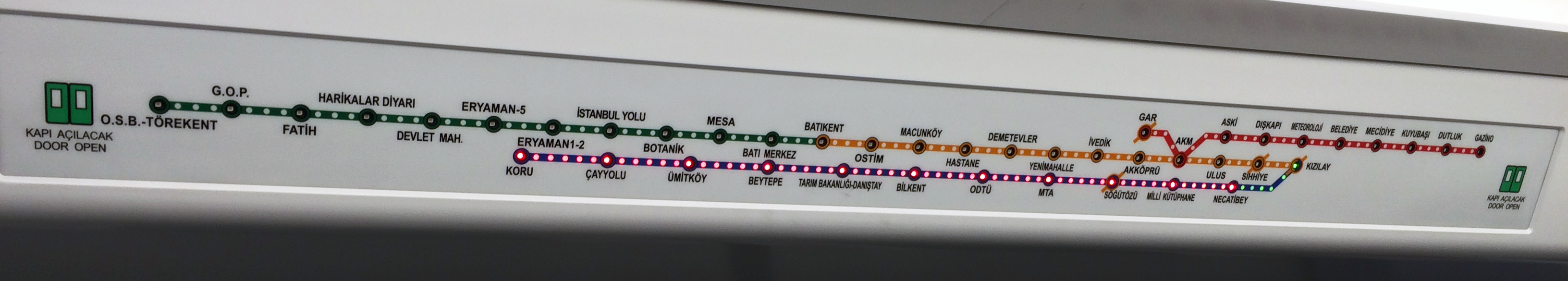
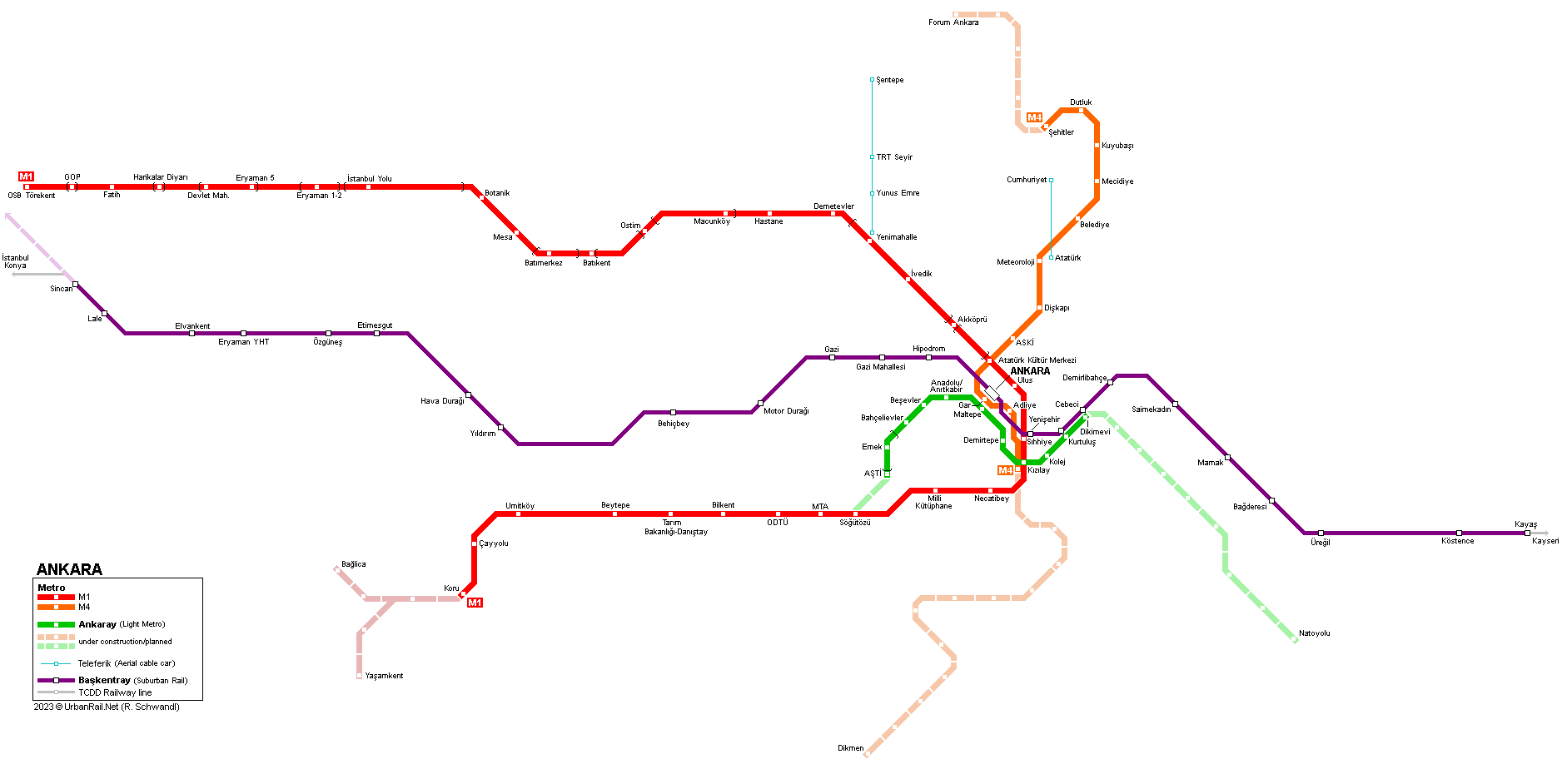
| The Turkish capital has some 3.5 million inhabitants in the metropolitan area. Currently there are two types of metro lines in service: | ||
| ANKARAY - A1 | ||
|
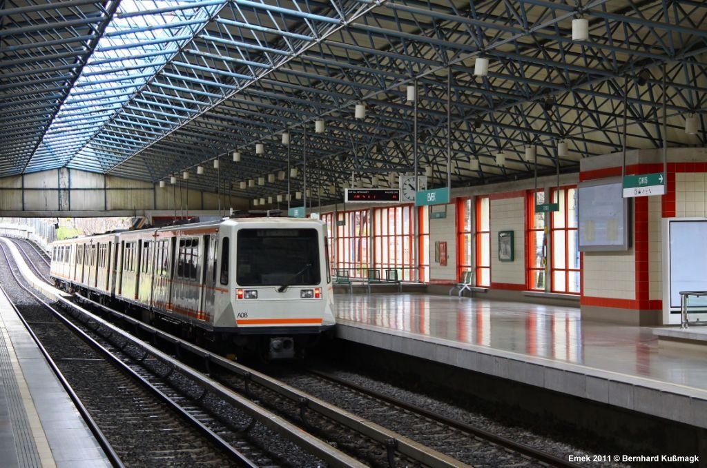
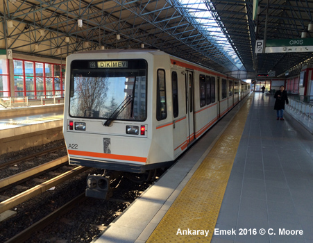
This is a light metro that runs between Dikimevi and ASTI: 8.5km (6.6km in tunnel, Emek station above ground), 11 stations, opened Aug. 30, 1996 after 4 years of construction work. - average
station distance 790m, 90m long platforms, 750 Vdc, third rail, built
by Siemens as a turnkey system 30 Aug 1996 - Ankaray ASTI - Dikimevi |
||
| METRO - M1 | ||
|
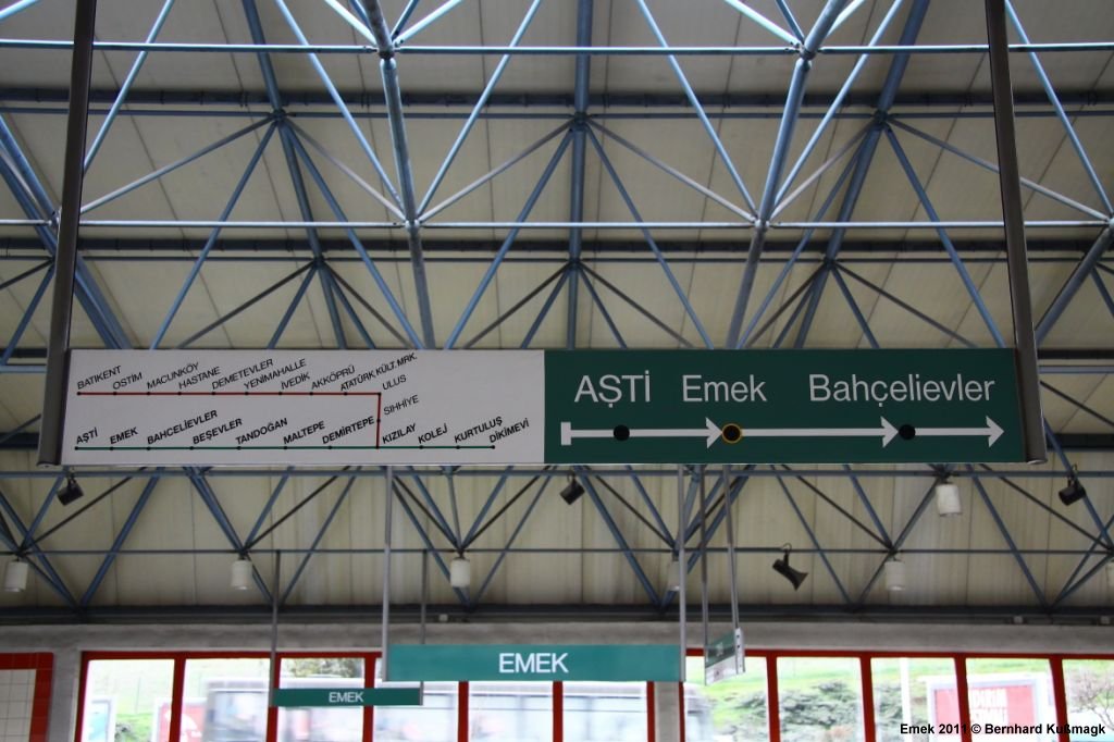
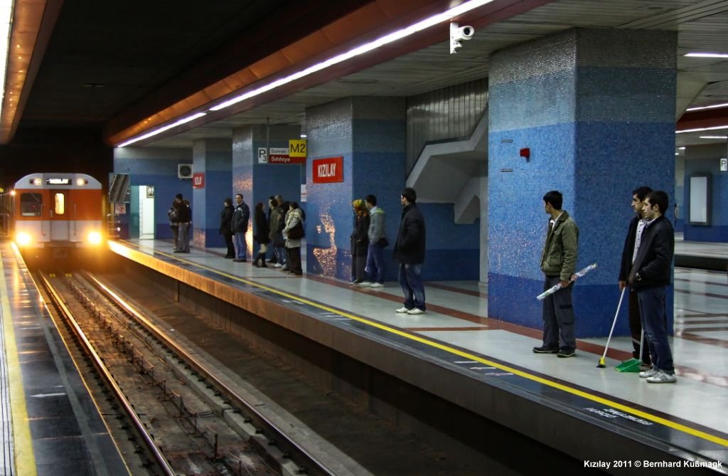
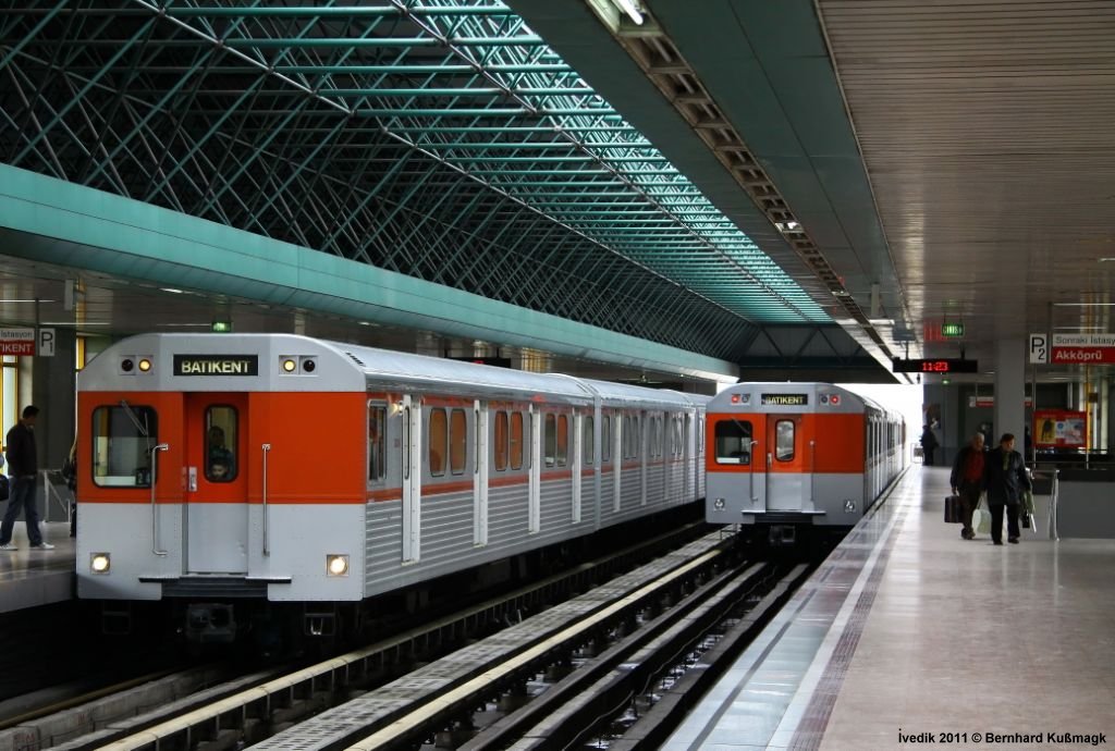
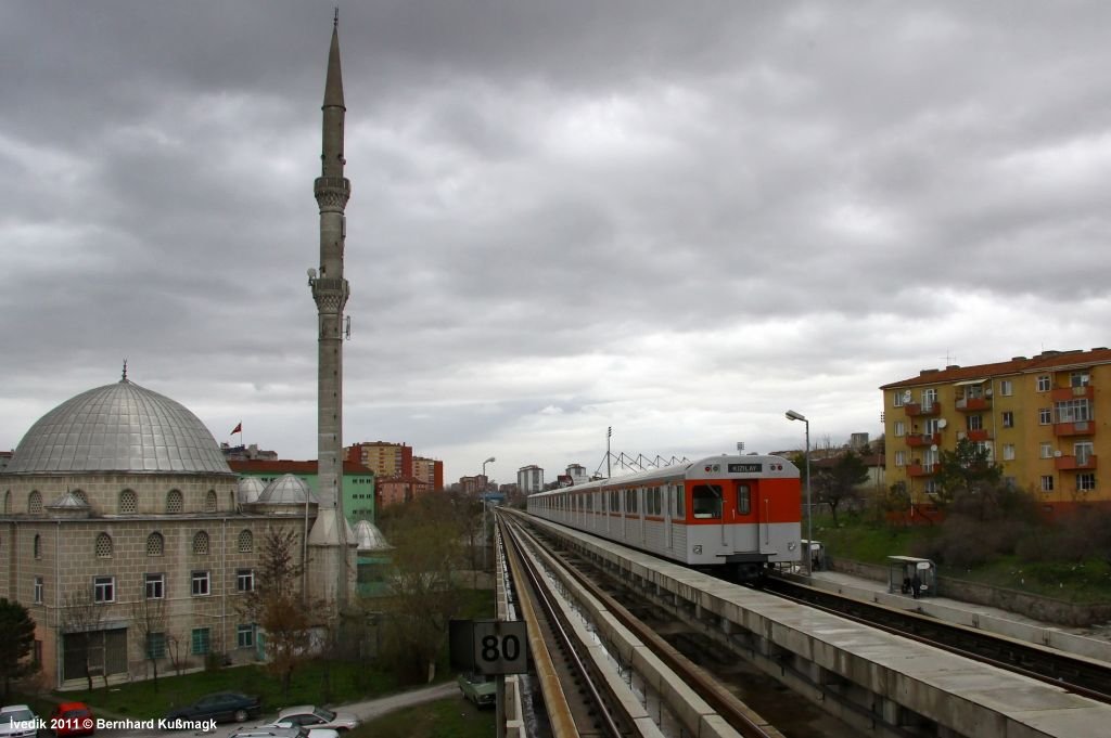
Ankara's first metro line initially ran from Kizilay to Batikent. Opened in autumn 1997 (construction work started 4 years earlier), it had 12 stations, and consisted of 6.5 km underground running, 4.9 km on the surface, and 3.2 km elevated. - 3rd rail
power supply (750V) The line was eventually extended at both ends in 2014, but was in fact operated as three separate services (M1-M3). 29
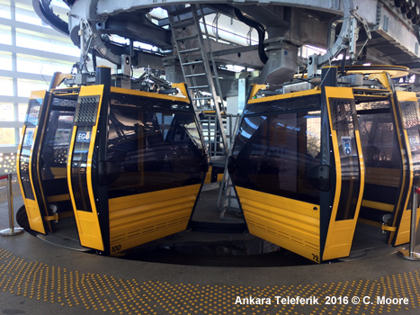
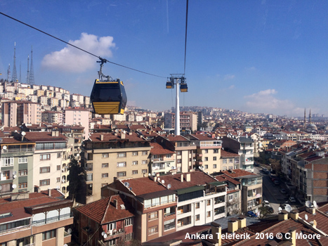
Dec 1997: Kizilay - Batikent (14.6 km) Since Feb 2019, the previously separate services (M1 Kizilay - Batikent; M2 Kizilay - Koru; M3 Batikent - OSB Törekent) have been operated as a single line M1. A 'Teleferik', an aerial cable car which functions as a metro feeder, opened on 19 June 2014 travelling north from Yenimahalle metro station. |
||
| METRO - M4 | ||
|
05 Jan 2017:
Atatürk Kültür Merkezi - Sehitler (M4, Keçiören
Metro, 9.2 km)
|
||
|
|
||
|
||
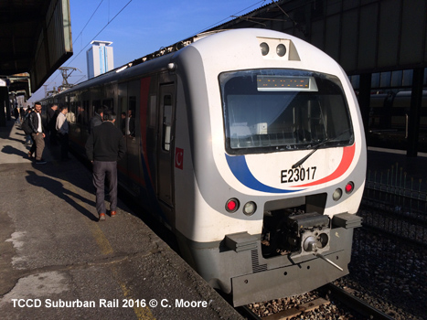
| BASKENTRAY | ||
|
Suburban railway, upgraded for metro-style service and reopened on 12 April 2018: Sincan - Kayas (37 km) Operated by E23000 EMUs from Hyundai-Rotem
|
||
|
|
||
|
Links
|
||
|
EGO (Official) RAYDER (Turkish Association of Rail Transport Systems) Ankara Metro & Ankaray at Wikipedia.tr Ray Haber (Turkish Rail News)
|
||
|
Photos
|
||
|
|
||
| Impressions | ||
|
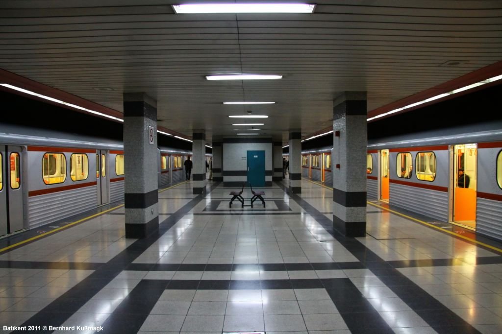
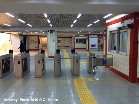
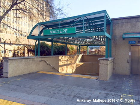
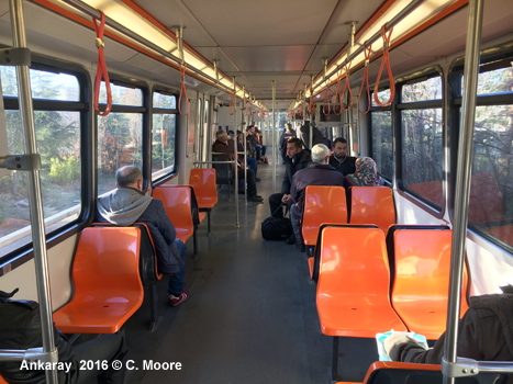
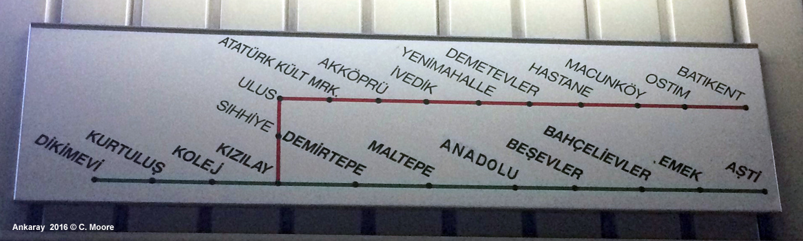
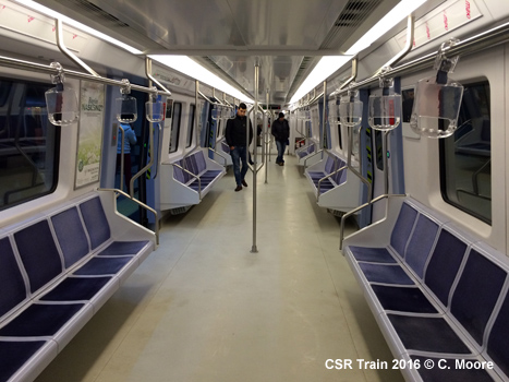
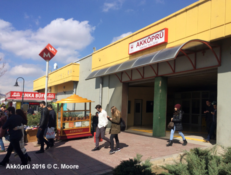
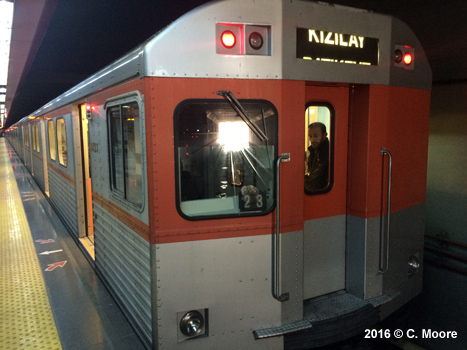
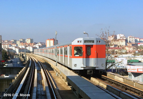
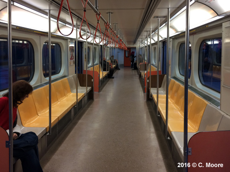
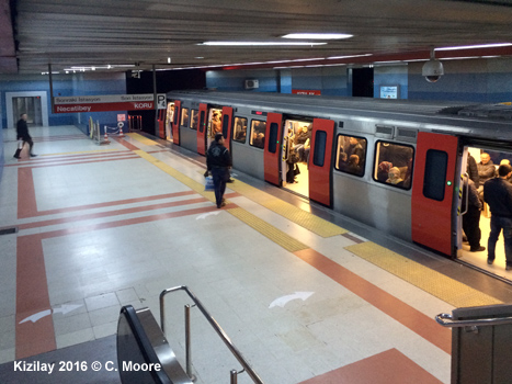
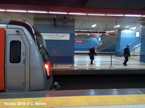
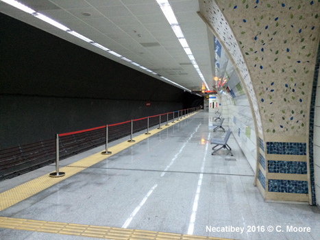
In March 2016, Craig Moore reports from Ankara: Located on the Anatolian steppe, Ankara is a largely twentieth century city built around a small, ancient township. Much of the city's urban rail service is relatively new, with the Ankaray Light Metro and Ankara Metrosu only beginning operations in the late 1990s. These lines greatly enhanced coverage that, until then was based on the Sincan-Kayas Banliyö Hatti - an established cross-city suburban rail line. Today, the city area has 92.5km of urban rail (40.2km underground) and hosts 73 stations. In infrastructural terms, the Ankara Metrosu is a 46.6km single line (32.4km underground), with 34 stations. The line operates from Torekent in the west to Koru in the south-west, via the city centre. Operationally, however, the line has been dissected into three: M1 is the original line, running from Ankara's urban rail hub at Kizilay in the city centre, to Batikent. This 14.6km section is the busiest of the three lines and operates from 0600-2330 with base headways of 8mins. In the centre, the stations are underground and accessed by open stairs at main junctions. The entrances are easy to locate in the streetscape thanks to high totems, topped with a distinct red cubed 'M'. Further north and west the station structures are at grade or elevated, are colourfully painted and have a large footprint. As such, they are discernible for quite some distance. At either end of the large entrance hall, ticket offices are located in the middle of two lines of ticket barriers (entry-exit). I saw no evidence of automatic ticket machines and you have to purchase card-based tickets from the ticket office. Entrance turnstiles include a ticket validating machine, which, once validated, releases the turnstile. Exit is via a free-turning turnstile. The main thing to notice is the quite desolate feel to the entrance hall. These halls are very large and are bereft of advertising, information boards and pretty much any other thing you would find in a Metro. There are no system maps at this level and only a basic A4 sheet stuck in the ticket office window showing the start-finish times of services. Rudimentary signage directs the passenger to the platforms via stairs and escalators. There is a mix of side and island platforms and here the deserted feel continues. Again, apart from a large schematic map located high on the platform walls, there is a lack of information or advertising and the small mosaic-sized tiles in muted tones, dark, heavy central support pillars, and dim lighting only add to the vacant feel. There are electronic indicators but these only provide the current time and give no indication of 'next train' arrival. As for the trains, the 6-car sets on M1 are the original Bombardier stock, with a metallic-burnt orange scheme and a dated look. The front of the train has a large drivers cabin at the right, with the left side just an empty space with no seating, although there is a front widow which offers a good 'driver's view'. The sheer number of portals and the undulating track make the view from the front/rear of the train very interesting. The trains are kept very clean and have side seating with plastic bucket seats as well as plenty of standing room. There is no system map on the trains and the basic strip map above the doors covers Line 1 and the Ankaray only (the original system). As for the route, the western end is mainly elevated, with short covered sections. This part of the line provides some wonderful views of the sprawling suburbs and mountains to the north. The sheds are located to the south of Macunköy and there is branch to the west of this station to provide access. This station also has a middle track where stock is stabled for peak services. At Yenimanhalle, the line offers barrier free interchange to the wonderful Teleferik (see below), before turning gently south toward the city centre. The line goes fully underground shortly before AKM. At both terminal stations the train arrives and departs from the same platform and there is cross-platform interchange with the connecting lines (M2/M3). At Kizilay, the station has two side platforms and an island platform. This allows both M1 and M3 passengers to alight or exit from either side of the train - the central platform providing access to the alternative line and the side platforms providing access to Ankaray services or exit stairs. M2 (16.6km) is fully underground and runs southwest from Kizilay to Koru. The stations are more tube-like and have brighter colour schemes and more interesting designs. M3 (15.4km) continues west after Batikent with elevated and underground sections. This is a new part of the city and the stations only add to the newness - they are fresh and bright, with interesting colour schemes, wall designs and working 'next train' indicators. Both M2 and M3 utilise smart new red/silver CSR stock. These trains operate three car sets, with the train stopping at the forward part of the platform, with the rear of each platform cordoned off by rope barrier. The stock has electronic strip maps with light indicators showing progress, and the map includes all lines, including the soon-to-be-opened M4. Like M1 stock, there is no system map on the trains but there is electronic and audio 'next station' information, with the audio in Turkish and English. This stock is bright and clean looking with cushioned side seating. Both these lines have the same operating hours as M1 although headways are currently 15mins. At Kizilay there is barrier free interchange with the Ankaray. The interchange is quite lengthy, the Ankaray line being below the M1/M3 platforms and at right angles. Green signage (as opposed to the red Metrosu signage) makes interchange navigation easy. This underground light metro line is 8.7km in length and runs from the ASTI bus station in the west, meandering eastward through the city centre to Dikimevi, coming up for air around Emek for 0.7km. The stations have a similar totem style to the Metrosu, but are adorned with a green cubed 'A' and station entrances have rather worn green/glass head houses covering the entrance stairs. The entrance hall, like that of metro stations is quite desolate and sterile with a small ticket office and a line of entrance turnstiles. Again there are no information boards. Stairs and escalators take you to smart platforms which have schematic maps, green station boards and electronic 'next train' indicators. The line operates from 0600-2345 and has a base headway of 6-8mins. The line is well used and the 3-car AnsaldoBreda sets are quite crowded. The interiors have orange plastic seats with double and single seat arrangements and plenty of room for standing. There is audio information in Turkish and an ugly strip map above the doors. Across the entire system flat fares are in operation (4TL/€1.25), and there is no Day Ticket. In general, information provision is poor - there are no schematic maps on trains, no geographic maps at all, no timetables and 'next train' indicators are at a premium, although interchange and navigation are relatively easy despite these information flaws. Overall, headways are adequate, the ride is smooth, quiet and fast, and once M4 is opened, the system will offer quite good coverage. Although the system functions well, the one thing that stands out is the lack of style and impact. The stations lack any charm, the stock (especially the Bombardier) is quite ugly, signage and information very basic and the whole system, whilst functional, lacks any elegance or character.
The national rail company (TCCD) operates the Sincan-Kayas Banliyö Hatti, a suburban railway line operating on an east-west axis from Sincan to Kayas through the city centre. The line is 37.2km in length and lies entirely at grade. Its 28 stations do not have physical connection with any of the Metrosu/Ankaray services; they are in quite a poor state of repair and are very basic, with a small ticket cubicle, a basic timetable poster at the turnstile entrance and long narrow island platforms. The line is certainly not of S-Bahn standard but it does warrant mention as it is fully urban and well used, and services offer a 20min headways during the day. The Hyundai Rotem stock operates in three-car sets with power from overhead catenaries and the trains have a smart white and blue exterior. The interior has a 2 x 2 seating arrangement, with space for standing. Basic strip maps are located above the doors and there is audio and electronic 'next station' information in Turkish. In the city centre, the train crawls quite slowly, but the line passes through interesting areas and so this gives an opportunity to view the surroundings. In peripheral areas the speed increases, but in general the infrastructure is somewhat worn and this is not a slick operation! Tickets are in the form of a little piece of paper and fares are distance based ranging from 2.35TL to 5.00TL (€0.73-€1.56). Although not urban rail, a final mention must go to the Teleferik. Like the Metrosu and Ankaray, this cable car is operated by EGO and acts as a feeder to M1 at Yenimanhalle. This is entirely free provision and is well worth a break of metro journey. There is barrier-free interchange with the metro on the west bound platform at Yenimanhalle. This is well signed and escalators lead the way to a smart but basic station. The 3.3km line opened in 2014 and has 4 stations spaced equally as it climbs the northern hills to Sentepe. At any one time there are over 100 cabins on the system and at the stations they bunch and move very slowly allowing easy access, with the cabin doors opening and closing automatically as it arrives/departs the platform. The cabins depart every 15 seconds and hold 10 people. Almost immediately the climb is steep and the views of the city to the south east, along the western developments and the urban density on the hills in the north are truly fantastic. The ride is very high above the ground and the journey takes 14mins to reach Sentepe. The 30min return is well worth it (for those who don't mind heights) and once back at Yenimanhalle, the metro entrance is 30m down the station building where another ticket purchase is required. Fantastic! |
||
2007 © Robert Schwandl (UrbanRail.Net)